1) We have lidar data for 2 new maps near Quincy.
2) We have some awesome terrain South of Cle Elum (2.5 hours drive time) for at least 2 maps.
3) Two maps close to Seattle in works (one likely to be cancelled).
I need help with field work.
Saturday, July 13, 2013
Sunday, June 23, 2013
Home-brew field work guidelines
We are getting ready to do some fieldwork in PNW Cascade foothill forest (think Tiger Mt. and similar).
I have prepared a contour+some trails map.
We will try to split the fieldwork; we are not qualified mappers; the end result is a "race-able" map.
This is the process description:
This is a document in making and I expect changes as we go along.
I have prepared a contour+some trails map.
We will try to split the fieldwork; we are not qualified mappers; the end result is a "race-able" map.
This is the process description:
- I will visit the area before hand and try to leave reference markers. Hopefully GPS coverage will be good.
- Thus I will have exact reference points on the map
- I will distribute the area by giving a proposed trajectory to those participating.
- I will print out the maps in twice the scale of the final version (e.g. 1:10000 will be printed as 1:5000)
- Information gathering protocol:
- GPS is always on
- I have means of putting GPS trace on the map very easily.
- When on field, follow route on map and add features to it
- Use 3 colors
- Use 2 usually, use third sometimes.
- more colors is messy and takes too much time
- Vegetation is encoded by the following number scheme:
- 0 - open forest (corresponds white map)
- 0-1 - open forest, bad undergrowth (white map, sparse green stripes)
- 0-2 - open forest, very bad undergrowth (white map close together green stripes)
- 1-, 2-, 3- correspond to different runnability of forest.
- 3 is reserved for blackberries and places you would never go yourself.
- 1- and 2- are somewhere in between
- 1- and 2- can be combined with the undergrowth symbol. 3 cannot
- In PNW forest 1- and 2- can happen with fallen trees or smaller trees.
- -1 and -2 describe the usual undergrowth in different forms of baddness.
- 2-0 is most likely to be used (and not 2-1). 2-2 is 3, 2-2 is not.
- 1-0, 2-0 is very unlikely either, there is always some undergrowth
- 2-1 and 2-2 is questionable.
- So the most common are:
- 0, 0-1, 0-2, 1-0, 1-1,1-2, 2, 3
- Please write them down as 0-2 or 0/2
- Pointwise features shall be kept as numbers that start with 10 and a list of the features on some side paper.
- Linear features:
- Distinct vegetation boundaries shall be kept with dotted line with first color
- Trails will be drawn as on map with first color
- Water features will be drawn with second color
- Contour line changes (hopefully not to be done), with third color.
- Area features:
- mark a region and add an explanation in the features list.
This is a document in making and I expect changes as we go along.
Saturday, June 22, 2013
OCAD for Homebrewing
There are some tips and tricks that make home-brewing OCAD editing much easier. Most of them can be found in the internets, but I have not seen nice sources.
- Hiding of symbol
- How:
- Select an object or symbol
- On keyboard: F4.
- All of the objects with the given symbol disappear.
- Do what you need to do
- select the symbol that was hidden.
- Click f2.
- You can do this also do a group of symbols - select everything and say F4
- This is useful for doing work in complicated/dense areas where lots of features are not allowing to draw clean lines. For example, when you are in a steep section with lots of contour lines, you may want to hide them.
- Following another line
- Why:
- there is a road somewhere and you need to have green on one side and yellow on other.
- you don't want to get the green on the other side.
- and you don't want the green to be away from the road.
- How:
- start drawing the line.
- press control, keep pressing it.
- click with mouse (left button) on the line you want to follow and keep holding it
- now move the pointer to the place till which you want follow
- release mouse
- the new line should be following
- Sometimes even with this feature you can see tiny white line. OCAD has bugs.
- Once you have two lines together and you need to shape them somehow together, you are in bad luck - I do not know how to do that nicely.
- Custom shortcuts:
- Why:
- once by computer, you need to be working fast, don't waste time
- use shortcuts!
- I use the following:
- ctrl+d for duplicate in place (fill, make border, duplicate identically in object menu)
- ctrl+f for forcing a different symbol (usually duplicate in place, then choose a symbol and then force a symbol on top)
- this is useful when creating borders of sorts or just making some contour line a lake or similar.
- ctrl+r - for reverse a feature - if you have a cliff with ticks to one side, this is how you can get them to another
- ctrl+t - for removal of vertices
- This was mentioned here.
Wednesday, April 10, 2013
Usage of NW trails/Switchbacks data
In some of the Homebrew maps I have been using NW Trails data - it has been in most cases used as a reference, but nevertheless, it has been.
So I need to give proper attribution.
From now on, I will make sure this happens better.
Their license, btw:
"Copyright © 2012 Jon Stanley
This software is provided 'as-is', without any express or implied warranty. In no event will the author(s) be held liable for any damages arising from the use of this software.
The accuracy of the data contained in this dataset varies greatly. These maps and data are to be used for reference purposes only. The author(s) are not responsible for any inaccuracies and no responsibility is assumed for damages or other liabilities due to the accuracy, availability, use or misuse of the data presented. Installation and use of this data is at your own risk.
Permission is granted to anyone to use this data for any purpose, including commercial applications, and to alter it and redistribute it freely, subject to the following restrictions:
1. The origin of the data must not be misrepresented; you must not claim that you recorded and compiled the original data.
2. If you use this data in a product, an acknowledgment in the product documentation is required.
3. Altered versions must be plainly marked as such, and must not be misrepresented as being the original data."
For amazing resources see this website:
http://www.switchbacks.com/nwtrails/
Tuesday, April 9, 2013
Willows training
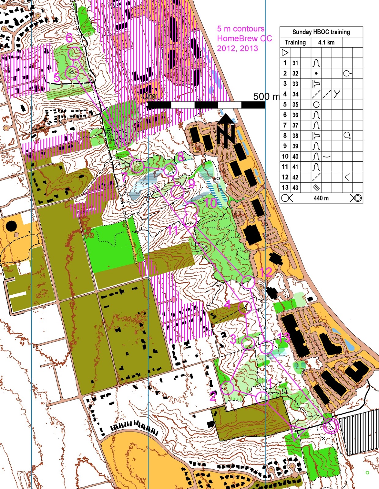
Ing, Gunta and Rick participated in Willows training on rainy Sunday, April 7th.
This is the map:
 PDF file can be acquired on request.
Note the forbidden and private areas - mostly ones with no trespassing signs.
Posession of the map does not grant you permission to go there.
Use it at your own risk.
This is the map:
Note the forbidden and private areas - mostly ones with no trespassing signs.
Posession of the map does not grant you permission to go there.
Use it at your own risk.
Sunday, March 24, 2013
Quincy 2 days have finished!
Excellent racers, excellent volunteers, excellent weather!
Quincy West:

Fast courses with shorter legs.
Some confusion was caused by Finish on first day - "Navigate to finish" says the description sheet.
https://www.5z.com/urban/gadget/cgi-bin/reitti.cgi?act=map&id=130&kieli=
http://www.obasen.nu/winsplits/online/en/default.asp?page=classes&databaseId=24649
Quincy South:

https://www.5z.com/urban/gadget/cgi-bin/reitti.cgi?act=map&id=131&kieli=
http://www.obasen.nu/winsplits/online/en/default.asp?page=classes&databaseId=24650
* Hannah's results are not recorded.
Special thanks to volunteers:
Help with children - Gunta & everybody else.
Control pickup - Nikolay, Dushka, Peteris, Richard, Andrew, Will, Susan, Barry.
Help with electronic equipment - Debbie, Ing, Don, Jan.
Routegadget - Jan
Cascade OC for renting me their SI stuffs.
Afterrace food - Marianne and Dobby.
(I am missing someone here, sorry about that).
Electronic maps of the race will be shared upon request.
Sunday, December 30, 2012
2.5 or 5 meters?
2.5 or 5 meter contour lines, that is the question.

 Thoughts?
I think I will go with 2.5 meter ones.


I think I will go with 2.5 meter ones.
Subscribe to:
Posts (Atom)